 |
| The White Rim Road stretches off into the distance. |
The trip had started off so well.
After getting to our second campsite on the White Rim Road, I walked to the edge and peered over at what had been the most terrifying part of the trip last time through: the dreaded switchbacks that led down the ridge at Murphy Hogback. A pleasant sight greeted me: the park service had smoothed the road out and gotten rid of the loose and crumbling rock along the ledge. Perhaps it was wishful thinking, but it even looked slightly wider. This was going to be a piece of cake! I went back to camp where we toasted another successful day on the rim of Canyonlands. We stayed up late that night, telling those that hadn't been with us in 2016 about discovering a wrecked truck at the bottom of the switchbacks and how the driver had been airlifted out just three weeks before we had gone through (you can read about our first trip
here).
 |
The new and improved Murphy Hogback route.
In 2016 this stretch of the road was covered with loose shale. |
The next morning as we packed up camp, Mark emerged from the camper with a grim look on his face.
"What's up?" I asked him.
"I don't want to tell you."
This is never a good sign.
He held out a clenched fist and opened his fingers. Lying on his dirt-laced palm was an eyebolt, sheered off at the base where it was supposed to be secured to the camper. Somewhere along the road the day before, the front driver's side bolt had snapped, leaving us with only three tie downs securing the camper to the truck bed.
 |
| The source of indigestion. |
We were forty miles from the nearest paved road, and about seventy miles to the nearest town. We still had 35 miles of rough, four wheel driving just to get out of this canyon. All these calculations were going through my head while we stared at the broken eyebolt.
Suddenly my oatmeal wasn't sitting so well.
We had extra turnbuckles with us, having learned our lesson ages ago when we lost a few in an accident (you can read about that one
here), but you need eyebolts to hook the turnbuckles in, so the extras wouldn't do us any good. Our friends offered a few solutions involving tow straps and ratchet systems, but none seemed viable. In the end, we decided to tighten the remaining three turnbuckles, drive as carefully as we could and keep our eyes on the mirrors. Our friend Mel helpfully offered to bring up the rear "in case you drop anything along the way."
Thanks Mel.
Now I suppose we could be the kind of people to play it safe and stay on nice smooth roads, camp in organized campgrounds, maybe stopping somewhere for ice cream in the afternoons. Sounds lovely don't you think? If a problem were to crop up, we could just cruise into the nearest mechanics shop, or better yet, head back home for a quick fix. For some unfathomable reason, we're not that kind of people.
Actually, other than the occasional hiccup like this, traveling on tough roads is completely fathomable.
 |
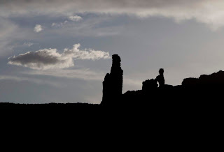
| A mesa at sunset looking for all the world like Australia's Uluru. |
There is little on earth that compares to finding yourself in a place where the lizards outnumber the people; where red monoliths soar hundreds of feet above your head, and huge rivers slide by another few hundred feet below. Lacing around Canyonlands National Park's Islands in the Sky District, the White Rim Road is 100 miles of 4WD trail that roughly follows the Colorado and Green rivers as they course through the park. Viewed from above, it looks kind of like a kindergartner's scribbled outline of the African continent.
Viewed from ground level, it's positively amazing.
 |
| Google's view of the White Rim Road |
 |
Our view.
Sunset on the White Rim Road
Canyonlands National Park
|
Six months before, our friends had texted us asking if we'd like to join them for another go on the White Rim. We had done it two years previous, but had to complete the trip in only two days, having only gotten reservations for one night. We had been unable to stop and check out many of the side trips and trails then, but this time around they were able to reserve two nights.
It made all the difference.
We had six vehicles in our group: Andrew in his Nissan Xterra, Craig and Rasa in their Toyota Tacoma, Ron in his brand new Chevy Colorado (brave man!), Mel in his Jeep Wrangler, George in his Mercedes Unimog accompanied by Ryan and LeeWhay, and of course we had our trusty Ford F250 with
Four Wheel Camper.
 |
| All but the Toyota. |
We started our trip at the Islands in the Sky Visitor's Center. After checking the conditions (always a good idea), checking out the displays and perusing the gift shop we were ready to go. We lined up at the entrance to the first challenge: the Shafer Switchbacks.
 |
The Shafer Switchbacks snake down the canyon joining the White Rim Road below.
|
This is always the most crowded spot on the White Rim. Many people make a quick day trip down the switchbacks, visit a few sites along the first few miles of the road, then head back up. We encountered lines of paid jeep tours, individuals in their vehicles, bicyclists and even a few photographers on foot coming back up as we descended. Luckily, this part of the road is pretty wide, or at least it has enough turnouts to give room to pass.
 |
| A bicyclist makes his way down the switchbacks. |
 |
| Descending the switchbacks |
 |
| The Mog and Chevy make their way down |
 |
| Andrew's Xterra is dwarfed by the massive cliffside |
We stopped in at the Gooseneck Overlook and...well...looked over. It was a great place to get some dramatic photos of the Unimog. George has a business importing these beasts and selling them here in the U.S. (You can find more about them at
UnimogCenter.com). As Andrew took some photos, the rest of us milled around and dared each other to get closer to the edge.
 |
| Andrew lines up a shot... |
 |
| ...of the Unimog on the edge... |
 |
...while we mill around.
(From left: Ron messing with his camera, LeeWhay, Mark, Rasa and Mel) |
 |
| The view of the river from Goosenecks. |
 |
| All lined up for the road ahead. |
 |
| Our first night was spent at Airport Campground. |
 |
| Our raven friend |
We spent the first night at the Airport campground, where we discovered we were being followed. Everywhere we stopped that day, a curious raven circled overhead and landed on various trees and bushes just out of reach. I'm not sure if he called ahead and alerted his buddies along the way, or if the same raven actually followed us throughout the trip (they don't wear name tags and they all dress alike). For two days, everywhere we stopped a raven would land nearby and monitor our progress.
 |
| The Airport Tower |
 |
| Some of the white rim has fallen down the canyon walls. |
 |
| A close up of the slick rock that makes up a lot of the roadbed. Beautiful, but it makes for slow driving at times. |
 |
| As the sun set that night, the shadows made castle-like outlines of the "fins" of the canyon. |
 |
| The formation known as "Washer Woman" looms above at sunset. |
In the morning we had a leisurely breakfast then headed off to our next stop: White Crack.
 |
Mark helpfully stands in as a scale marker.
White Crack |
White Crack, besides being the fodder for countless schoolyard jokes, is a long deep crack in the white layer of rock that is the namesake of White Rim Road. It's located at about the halfway point on the southern-most tip, down a one mile side road. A short hiking trail from the parking area leads to the crack, and a gorgeous view of the canyon.
 |
| We found a baby rattlesnake hiding under some brush. |
We stopped here and there along the road during the ride to take photos and generally oohh and awww over the scenery. Driving along sheer cliff edges, and sometimes
on the overhanging rock never fails to give you the willies. Strict attention to the road is a must, and it's nice to get out and enjoy the view without risking a painful and possibly fatal mistake.
 |
| The view from the end of the trail. |
 |
| The crack |
 |
| The road cuts between mesas in the distance. |
Our second night's reservations were at Murphy Hogback, the site of my mental anguish from the previous trip. Before discovering our broken eyebolt, we enjoyed it thoroughly; I think it was my favorite campsite on the White Rim.
 |
| The impossibly wonderful view |
 |
| Andrew starts up Murphy Hogback as Mel waits his turn |
 |
| Yes, it really is that steep in places. |
 |
| What it looks like from the cab as you go up the switchbacks |
 |
| The view back where we came from |
 |
| A lizard poses for a shot |
 |
| Ron sets up in Murphy Hogback Campground |
 |
| Sunset that night |
 |
| The Mog disappears down Murphy Hogback |
 |
| Our tiny friends are reflected in the mirror as we make our way down. |
The entire trip we teased George about the upcoming narrow parts of the road. To this point, the Unimog, as big as it is, had easily fit on the tightest switchbacks and under the lowest overhangs. We all recalled a bad part toward the end of the road, but couldn't quite figure out if it would be a problem. We had all been driving more conventional vehicles, and our F250 and camper combo was the tallest at the time, but the Unimog is a couple feet higher and eight inches wider. Sure enough, just a few miles from the end of the road, we found the spot:
 |
| George inspects the lack of clearance before going forward... |
 |
| ...and makes contact with the wall. |
 |
| And we thought we were big. |
The Mog lost a little paint, but thankfully nothing serious happened to the box. I think we found the size limit for the road.
Once out of the canyon, we found a nice campsite on the rim. We had kept an eye on the camper the whole day and were happy to discover it had only shifted a little bit in the bed of the truck. We were confident that with careful driving we would be fine until we got home, where Mark would replace all four bolts for good measure.
When we opened the camper door that afternoon we discovered the only other minor mishap; the stops on our utensil drawer, after 15 years of this kind of abuse, finally rebelled. The drawer had broken it's moorings, scattering knives, forks and spoons all over the cabin. Easily repairable and no harm done.
Things we learned on this trip:
- Never buy dish soap with a flip top. When it falls over in the cabinet knocking the top open and surreptitiously leaks into the bowls, it makes your oatmeal taste like Palmolive.
- Things that keep you up worrying all night are never as scary in the morning.
- When you tell them your great ideas about places to explore, good friends will nod and say "that sounds nice." Better friends join you for the ride.
Here's a recipe we used to celebrate a successful trip:
White Rim Margaritas
- Run a slice of fresh lime around rim of glass and dip into kosher salt
- Muddle one slice of fresh jalapeño and a some cilantro leaves in the bottom of the glass
- Add chilled pre-mixed Lime Margarita and a splash of Lime bubble water (we used La Croix)
- Add no ice cubes, because you've been on the road too long and all the ice melted
- Toast the fact that you made it out in one piece and enjoy
(Disclaimer: only make these once your driving is done for the day.)


